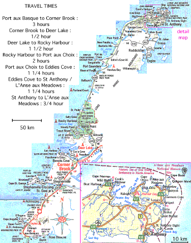
Generally, you can't count on good clear weather. Remember that a good portion of the trip hugs the coast line, with fast changes of conditions and fog a common occurrence. Most of the road is two lane, all hard top. A few sections around Corner Brook are four lanes. Most of it is posted at 90 kph, but the 'real' speed is closer to 100 - 110. Unfortunately, some sections of the road, most notably just north of Rocky Harbour on the West Coast, are in rough shape. A heavily loaded vehicle will be hard pressed to even maintain the speed limit in some places. The most famous traffic hazard is 'Moose on the Highway', most common at dawn and dusk, especially in the early spring and fall. On one evening trip from Rocky Harbour back to St Anthony, we counted almost 50. Around Gros Morne Park and across the neck of land before St Anthony you can count on Caribou as well. If you are a timid driver, your best bet is to get in behind a transport truck. One of the other (problem) things about travel in Newfoundland - the signage is generally terrible. Islanders don't travel out much, so they already KNOW where almost everything is locally. It is rare to find "500 m to..." type warning signs, other than the ones posted for highway and community locations. Most of the time, signs are attached flat on the front of buildings. This means that by the time you figure out the building IS a restaurant - you are well past being able to stop for it. Best bet is planning ahead to stop in a community - THEN driving around town to find the single open food stop. First thing to know is that your have to make a turn off IMMEADIATELY outside of the ferry parking lot if you want to get into town. Otherwise you are straight on to the trans Canada highway, and almost right away into empty landscape. There is ALWAYS a huge amount of jockeying on the road, as the hot shots try to jag around the winnibeggos. (A hint on this on the other end - first ON the ferry is first OFF the ferry! Arrive early and grab lunch before boarding.) The road runs up into some low mountains. Its a gentle slope, but it puts you into terrain that looks like peat bogs - and almost always has fog. After a bit you will start to get tired of the spruce trees, but that's about it for the next few hours. All the communities in this area are quite far off the main road and easily missed. At Corner Brook itself, the highway runs past the city. You will have to get off to even see town. The southern exit is the one that leads to the 'mall strip' and the easiest way into down town. The first bit of this, up to Deer Lake and the airport there, is pretty much all four lane and 100 kph speed limit. Its a good idea to make sure that you are fully gassed up before leaving Deer Lake, the stations are spread pretty far apart from then on. Not too far north of this, the terrain gets very rough - with several extremely steep grades both up and down. Spectacular scenery, with the fiord and mountains at the south end of Gross Morne National Park The road along this whole stretch hugs the coast, and turns and twists all over. It surface also suffers from winter frost heave. The section along the top end is especially horrible. Add the Moose (a lot more up here) and it generally means taking it easy on the road. Did I mention that gas and food is pretty spotty? By the end of this leg, you may be getting a bit tired of 'yet another picturesque fishing village'. Once you get away from the coast, its flat. Its empty. Its pretty boring. Its REAL empty - there is not a single building between Eddies Cove east to the St Anthony airport (45 minutes). There's hardly another one until you get close to St Anthony proper. The section of road from the turn off for L'Anse aux Meadows to St Anthony is also in poor shape. As I mentioned with the ferry information, you likely will have two options on your trip up the Island. the real hard core travelers will take the night crossing, try to grab some sleep on a bench - and then drive all day to make St Anthony late in the day . I usually spring for the cost of an open berth - about $15. This gives you a bunk in a room full of them, with luck you'll be asleep before the boat even leaves the dock. An extra blanket is a good idea. If you are planning to spend a day at Gross Morne National Park (highly recommended!) this option will get you to the park by late afternoon, with enough time to get camp set before evening. If you take the mid day ferry (easiest in terms of travel times getting out to Atlantic Canada) you are going to be dropped off at around 5 - 6 pm. This means you can make Corner Brook about dark. Unless you are intending to stay in a hotel, there is not very much camping available in that area. The only Provincial camp ground is about 20 minutes south of Corner Brook (Blue Ponds). There are a number of excellent Provincial camp grounds in the lower end of the first leg - a total of three along the first 30 minutes (Cheeseman / Mumminchog / Grand Codroy). Note that ALL of these are off the main highway and easy to miss. the next is about the one hour mark (Crabbeąs River) and the last about two hours along (Brachois Pond). A cautionary word about speed. First - you'll hardly ever see a police car. But watch the roads - especially in the north! Not only are there long sections with very bad pot holes - the roads suffer extreme frost heave. This creates sections that will suddenly have accordion ripples in them. At speed, or in a heavy vehicle, this can set up a bouncing that can destroy running gear or even toss you off the road. I have had expensive repairs after three of my trips. As you might guess from all that - I HIGHLY recommend the Provincial camp grounds! The tent sites are generous in size, and spread out enough that you can hardly tell you have neighbours. They are clean and well serviced. All that and cheap too! In 1997 the one night fee was only $10. For more information, check the web site: My best recommendation, especially if this is your first time on the Rock, is to take it a bit easy on the way up and take the extra time to see the ground. Getting to the noon crossing, followed with a night at either Barachois Pond or Blue Ponds will be a pretty full day. This leaves you with a good eight hours drive the second day, and will get you to St Anthony area about supper time. (Note that this also works well for the reverse trip, putting you into Louisburg about supper the second day.) Just as a side note, there are no major camp grounds north of Gross Morne (about the middle of the distance) until you get up near St Anthony. |